 Metainformationssystem GDI-BW
Regional
Type of resources
Available actions
Topics
INSPIRE themes
Keywords
Contact for the resource
Provided by
Years
Formats
Representation types
Update frequencies
status
Service types
Scale
Resolution
-

Since the end of the 1980ies the geological, areal and production data of operating mining sites have been collected systematically by LGRB. The periodic update of this information is carried out every four or five years. Main reasons are 1) the preparation of the periodic follow-up of the 12 regional development plans, 2) the work on the near-surface mineral raw material maps published by LGRB, and 3) the periodical editing of the state report for near-surface mineral raw materials published by LGRB at the start of each new election period. The geological data include a detailed documentation of the thickness, petrography and quality of mined rock(s) and the overburden as well as geochemical data gained from rock samples. The areal data refer both to the permitted mining area (zones of recultivation, work and expansion) and to possible areas for the mine expansion (the latter are confidential). Due to the quick spatiotemporal variability of these data, here all mining sites are shown as point data. The confidential annual production data are the basis for the periodic raw material report. In addition, another data are collected, e.g. for the mining permission, the delivery area and the subsequent land use. All these data are stored in the mining site database of the LGRB (Rohstoffgewinnungs-stellendatenbank = RGDB). This one comprises also the data for abandoned mining sites and mines. In total, actual (2021) about 14.000 data records are stored. The name of each mining site (e.g. RG 6826-3) consists of three parts. RG is the abbreviation for "Rohstoffgewinnungsstelle". the following four-digit number means the number of the relevant topographic map 1 : 25.000. The last number means the serial number of the mining site; serial numbers 1-99 mark operating mining sites gathered since the end of the 1980ies ( (today partially already closed) , such > 100 mark abandoned mining sites collected before 1980 and such > 300 mark data of mining sites and mines collected in the course of actual raw material mapping. The mintell4eu data set comprises all mining sites with serial numbers 1-99. In addition, the most important abandoned mines of former or probably still ongoing economic importance.
-
Since 1999, the Geologic Survey of Baden-Württemberg publishes a statewide geological map series 1 : 50 000 "Karte der mineralischen Rohstoffe 1 : 50 000 (KMR 50)". On it, the distribution of near-surface mineral raw material prospects and occurrences (mainly) and deposits (subordinate) is shown. This continuously completed and updated map currently covers around 60% of the federal state. It is the base for the regional associations in the task of mineral planning. The prospects and occurrences are classified according to different raw material groups (e.g. raw material for crushed stone (limestone, igneous rocks, metamorphic rocks, sand and gravel), raw materials for cement, dimension stone, high purity limestone, gypsum ...). Their spatial delineation is based on various group-specific criteria such as minimum workable thickness, minimum resources, ratio overburden/workable thickness, and so on. It is assumed that they contain deposits as a whole or in parts. In the vast majority of cases, the data is not sufficient for the immediate planning of mining projects, but it does facilitate the selection of exploration areas. The name of each area (e.g. L 6926-3) consists of three parts. L = roman rnumeral fo 50, 6926 = sheet number of the topographic map 1 : 50 000, 3 = number of the area/mineral occurrence shown on this sheet. Co-occurring land-use conflicts, e.g. water protection areas and nature conservation areas, forestry and agriculture, are not taken into account in the processing of KMR 50. Their assessment is the task of land use planning, the licensing authorities and the companies interested in mining. The data is stored in the statewide raw material area database "olan-db" of the LGRB.
-

This Downloadservice contains point locations of near-surface mineral raw material occurrences and mining sites in Baden-Württemberg (BW), which is one of 16 states of the Federal Republic of Germany. The information is harmonized according to the specifications of the MIN4EU database model as part of the Mintell4EU project. BW is rich in near-surface mineral raw materials. The most important are 1) Quaternary sands and gravels (Upper Rhine Graben Valley and glacial sediments of Upper Swabia), 2) Paleozoic rocks (mainly metamorphic rocks and granites, minor Permian volcanic rocks) in the Black Forest and the Odenwald, and 3) Middle Triassic (Southwest German scarplands) and Upper Jurassic (Swabian Alb) limestones. The deep-lying raw materials (various gangue ores, barite, fluorite, uranium ores), which were mined mainly in the Black Forest, are currently of no importance, with the exception of the still ongoing extraction of barite and fluorite in the Clara mine. In the future, some deposits could regain importance as raw material prices rise. Almost 100 million tons of mostly near-surface mineral raw materials are extracted annually in BW in currently about 500 mining sites (survey year: 2017). The annual raw material consumption is approx. 9 tons/inhabitant. At the beginning of the 2000s, there were still around 630 mining sites. This decline is due to both concentration processes and depletion of deposits. Since the end of the 1980ies the geological, areal and production data of operating mining sites have been collected systematically by LGRB. They are the basis for the periodic raw material report edited by LGRB and for the calculation of the need of mineral raw materials. Manly these pits, beside some important historic mines, are shown in the layer "MIN4EU LGRB-BW: mining sites - harmonized dataset". Another important task of the LGRB is to advise the regional planning authorities on securing mineral raw material supply. Beside the calculation of the need of mineral raw materials supply for the two planning periods (2 x 15 or 2x 20 years), the knowledge of mineral occurrences of proven or estimated economic value is important. After some preliminary stages, the LGRB is producing the Map of Mineral Resources in Baden-Württemberg 1 : 50,000 (KMR 50) as a basis and planning map for this purpose. On it, the distribution of near-surface mineral raw material prospects and occurrences (mainly) and deposits (subordinate) is shown. This continuously completed and updated map currently covers actually around 60% of the federal state. These occurrences are the topic of the second layer theme "MIN4EU LGRB-BW: near-surface mineral raw material occurrences - harmonized dataset".
-

Der Bebauungsplan (verbindlicher Bauleitplan) wird aus dem Flächennutzungsplan entwickelt. In ihm werden die Darstellungen des Flächennutzungsplanes parzellenscharf konkretisiert. Bspw. kann aus einer im Flächennutzungsplan dargestellten Wohnbaufläche sowohl ein reines als auch ein allgemeines Wohngebiet entwickelt werden. Der Bebauungsplan beinhaltet die rechtsverbindlichen Festsetzungen für die städtebauliche Ordnung und schafft damit die Voraussetzungen für die Bebaubarkeit von Grundstücken. Diese Festsetzungsmöglichkeiten sind abschließend im Baugesetzbuch geregelt und können nur aus städtebaulichen Gründen angewandt werden. Bebauungsplan Nr. 3 / 12 Albstadt Burgfelden
-

Das Basis-DLM ist neben anderen DLM und sonstigen digitalen Datnesystemen (DTK, DGM, DOP) Bestandteil des Amtlichen Topographischen-Kartographischen Informationssystems (ATKIS). Digitale Landschaftsmodelle (DLM) modellieren die Landschaft objektstrukturiert in Vectorform. Kennzeichnend für das DL; ist die maßstabslose, lagetreue Modellierung der punkt-, linien- und flächenförmigen Objekte, die in ihrer Gesamtheit die gesamte Fläche Baden-Württembergs lückenlos bedecken. Das DLM kann mit geeigneten Prozeduren (Generalisierung, Signaturierung) in die Digitale Topographische Karte (DTK) überführt werden. Eine Visualisierung in einfacher Form für technische Anwendungen im Maßstabsbereich 1 : 5 000 bis 1 : 10 000 genügend ist auch einen Generalisierung möglich. Koordinatendimension: 2D (keine absolute Höheninformation), Einheiten der ebenen Koordinaten: Meter. Reale Welt (Landschaft) wird mittels Objekten (punkt-, linienförmig, flächenförmig) modelliert.
-
Das Gewässernetz 1:50.000 enthält (nur) die Gewässergeometrien im Maßstab 1:50.000 für die Fließgewässer aus dem Gewässernetz 1:10.000 (Fluss10). Sachdaten werden nur im Gewässernetz 1:10.000 geführt. Eine Fortschreibung erfolgt seit Dezember 2005 nicht mehr.
-
Das Gewässernetz 1:1.000.000 enthält (nur) die Gewässergeometrien im Maßstab 1:1.000.000 für eine maßstabsgerechte Auswahl aus den Fließgewässern des Gewässernetzes 1:10.000. Sachdaten werden nur dort geführt.
-
Enthält (nur) die Einzugsgebietsgeometrien im Maßstab 1:200.000 für die Einzugsgebiete von EZG10. Dies jedoch nur für die Gewässer der Fluss10-Ausdünnungsstufe 1:200.000. Sachdaten werden nur in EZG10 geführt.
-
Es liegen Geodaten zur Klassifizierung der Bilddaten der LANDSAT 2-Multispektral-Aufnahmen (Raster 79m x 56m) vom 8./9. August 1975 vor. Die Ergebnisse dieser Klassifizierung liegen im Raster von 50m x 50m (5590 Zeilen und 5200 Spalten) vor. Unterschieden werden bei der Landnutzung 10 Klassen: Laubwald; Nadelwald; Mischwald, Siedlung - lockerbebaut; Siedlung - dicht bebaut; Industrie; Grünland; Ackerland; Wein- und Obstbau; Gewässer.
-
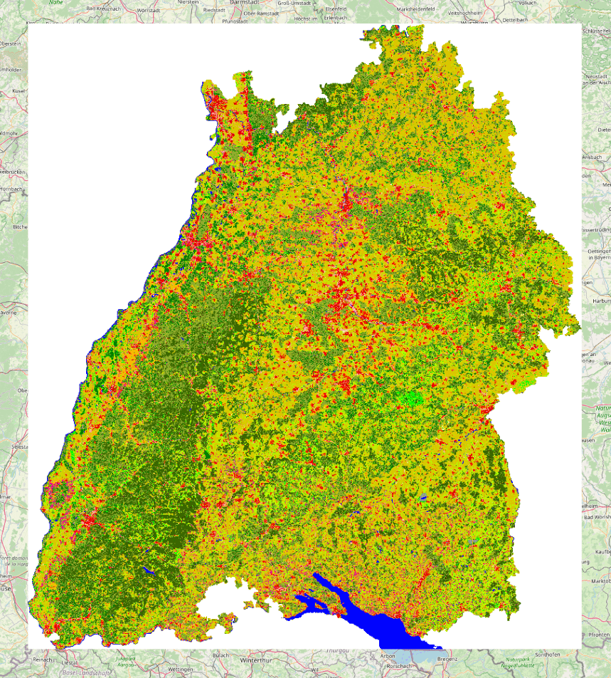
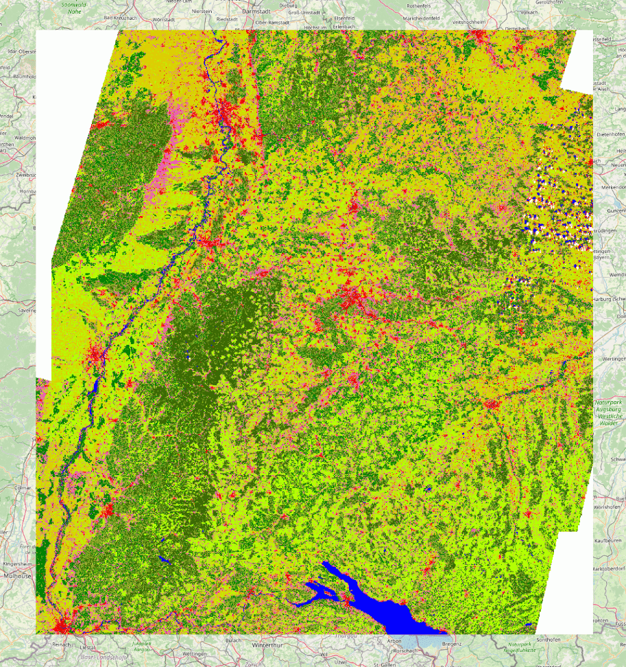
Mit der Satellitenbildauswertung sollen aktuelle Landnutzungsdaten für Baden-Württemberg für Umweltzwecke bestimmt werden. Dafür wurden multispektrale LANDSAT-TM5 Datensätze der Jahre 2009 und 2010 verwendet. Mit Erstellung dieser Landnutzungskarte wird eine vergleichbare, durch die LUBW beauftragte Erhebung aus dem Jahr 2000 fortgeführt. Der bereitgestellte Datensatz ist nach gebietsweit einheitlichen Kriterien erarbeitet worden und aus techn. Gegebenheiten des Satellitensystems heraus in einem Maßstabsbereich ab ca. 1:100.000 anwendbar. Die Daten liegen flächendeckend in einer Auflösung von 30 x 30 Meter vor. Maßstab: 1:25000