 Metainformationssystem GDI-BW
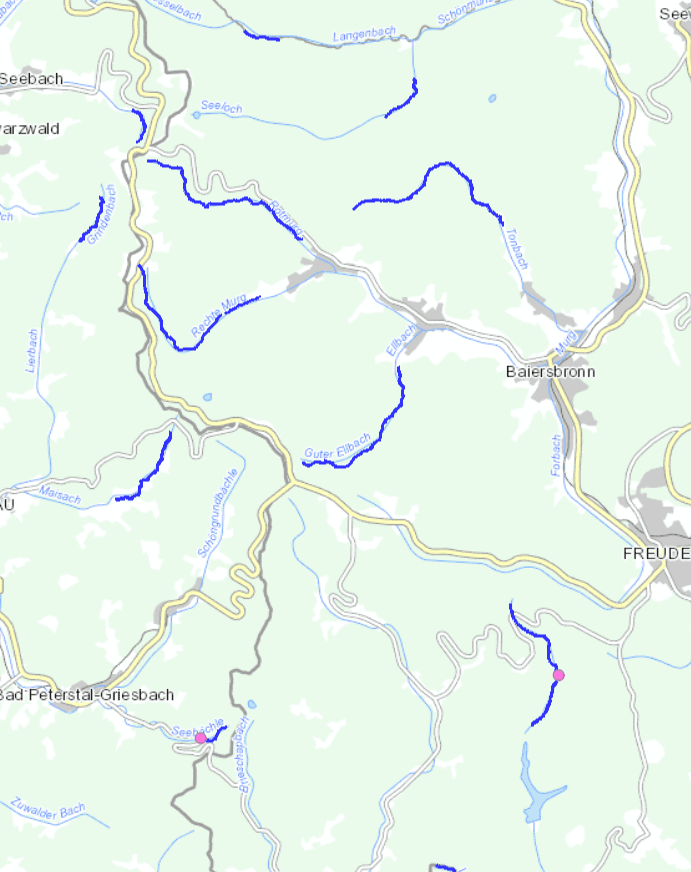
Referenzgewässerstrecke
Landesweite Auswahl repräsentativer Fließgewässerstrecken. Darstellung des typspezifischen Referenzzustandes als Grundlage für die hydromorphologische Bewertung im Sinne der WRRL sowie als Arbeitsgrundlage bei der Konzeption und Planung typspezifischer Maßnahmen.
Simple
- Date (Publication)
- 2019-10-07T00:00:00.000+02:00
- Citation identifier
- https://registry.gdi-de.org/id/de.bw.lubw.mdk/c0b75849-5bb0-4964-b19f-7ff305675b65
- Purpose
-
Grundlageninformation für interessierte Öffentlichkeit und Träger der Gewässerunterhaltungslast und -ausbaulast.
- Status
- Completed
- Point of contact
-
Organisation name Individual name Electronic mail address Role LUBW Landesanstalt für Umwelt Baden-Württemberg
UIS-Geodatenmanagement, RIPS-Metadaten
rips-metadaten@lubw.bwl.de metadaten@lubw.bwl rips-metadaten@lubw.bwl.de
Point of contact LUBW Landesanstalt für Umwelt Baden-Württemberg
UIS-Geodatenmanagement, RIPS-Datenabgabe
rips@lubw.bwl rips@lubw.bwl.de
Distributor
- Maintenance and update frequency
- As needed
- Update scope
- Dataset
-
UMTHES Thesaurus
-
-
Gewässerschutz
-
Oberflächengewässer
-
- Keywords
-
-
oac:688
-
- Use constraints
- Other restrictions
- Other constraints
-
Es gelten die Bedingungen der Nutzungsvereinbarung für Daten des UIS " https://www.lubw.baden-wuerttemberg.de/umweltinformationssystem/nutzungsvereinbarung"
- Spatial representation type
- Vector
- Denominator
- 10000
- Language
- Deutsch
- Character set
- UTF8
- Topic category
-
- Inland waters
- Farming
- Environment description
-
Keine Angabe zur Hauptanwendung
- Description
-
Baden-Württemberg
- Extent type code
- Yes
- Geographic identifier
- DE1
))
- Unique resource identifier
- EPSG 25832: ETRS89 / UTM Zone 32N
- Topology level
- Topology 1D
- Geometric object type
- Curve
- Geometric object count
- 386
- Distribution format
-
Name Version
- OnLine resource
-
Protocol Linkage Name https://udo.lubw.baden-wuerttemberg.de/public/index.xhtml
- Hierarchy level
- Dataset
- Statement
-
Das Vorgehen ist in der Handreichung "Gewässerentwicklung und Gewässerbewirtschaftung in Baden-Württemberg - Teil 2 Referenzgewässerstrecken" erläutert. https://pd.lubw.de/83313
Metadata
- File identifier
- c0b75849-5bb0-4964-b19f-7ff305675b65 XML
- Metadata language
- Deutsch
- Character set
- UTF8
- Hierarchy level
- Dataset
- Date stamp
- 2024-03-15
- Metadata standard name
-
ISO 19115:2003 (GDI-BW)
- Metadata standard version
-
2.1
- Metadata author
-
Organisation name Individual name Electronic mail address Role LUBW Landesanstalt für Umwelt Baden-Württemberg
rips-metadaten@lubw.bwl.de metadaten@lubw.bwl rips-metadaten@lubw.bwl.de
Point of contact
Overviews
Spatial extent
Provided by
