Metainformationssystem GDI-BW
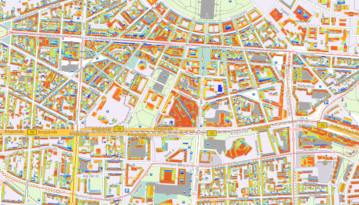
Dach-Photovoltaik (Potenzial)
Im Rahmen des "Energieatlas Baden-Württemberg" wurde auf der Grundlage von hochaufgelösten Laserscandaten die Eignung von Dachflächen für Photovoltaikanlagen ermittelt und das solare Energiepotenzial auf Dachflächen (in kW) für ganz Baden-Württemberg flächendeckend berechnet.
Die Potenzialanalyse bezieht sich dabei auf Standortfaktoren wie Neigung, Ausrichtung, Verschattung und solare Einstrahlung. Die Berechnung dieser Faktoren erfolgte über ein digitales Oberflächenmodell.
Simple
- Date (Revision)
- 2016-02-23T00:00:00.000+01:00
- Citation identifier
- https://registry.gdi-de.org/id/de.bw.lubw.mdk/6d21c3ec-e6ec-4762-a11c-b64ca2b03938
- Purpose
-
-
- Status
- Completed
- Point of contact
-
Organisation name Individual name Electronic mail address Role LUBW Landesanstalt für Umwelt Baden-Württemberg
UIS-Geodatenmanagement, RIPS-Metadaten
Point of contact
- Maintenance and update frequency
- Irregular
- Update scope
- Dataset
- Keywords
-
-
Energie
-
Klima
-
- Keywords
-
-
oac: 541
-
- Use constraints
- Other restrictions
- Other constraints
-
Es gelten die Bedingungen der Nutzungsvereinbarung für Daten des UIS " https://www.lubw.baden-wuerttemberg.de/umweltinformationssystem/nutzungsvereinbarung"
- Spatial representation type
- Vector
- Denominator
- 2000
- Language
- Deutsch
- Character set
- UTF8
- Topic category
-
- Environment
- Utilities communication
- Economy
- Environment description
-
Energieatlas Baden-Württemberg (EEBW)
- Description
-
Baden-Württemberg
- Extent type code
- Yes
- Geographic identifier
- Raumbezug des Datensatzes
))
- Unique resource identifier
- EPSG 25832: ETRS89 / UTM Zone 32N
- Topology level
- Full planar graph
- Geometric object type
- Surface
- Geometric object count
- 3400000
- Distribution format
-
Name Version
Distributor
- Distributor contact
-
Organisation name Individual name Electronic mail address Role LUBW Landesanstalt für Umwelt Baden-Württemberg
UIS-Geodatenmanagement, RIPS-Datenabgabe
Distributor
- OnLine resource
-
Protocol Linkage Name https://udo.lubw.baden-wuerttemberg.de/projekte/
- OnLine resource
-
Protocol Linkage Name https://www.energieatlas-bw.de/sonne/gebaeude/karten?activeLayer=solarkataster Energieatlas BW: Potenzial Dach-Photovoltaik
- Hierarchy level
- Dataset
- Statement
-
Das Solardachkataster ist die räumliche Darstellung eines auf Geodaten basierenden Analyseverfahrens, mit dem es möglich ist, solare Potenziale von Gebäudedächern großflächig zu erfassen. Dabei wurden Dachfläche, Ausrichtung, Neigung, Globalstrahlung und Abschattungseffekte berücksichtigt.
- Description
-
Der Prozess zur Verarbeitung der Datengrundlagen wird im Energieatlas BW unter https://www.energieatlas-bw.de/sonne/gebaeude/grundlagen#Potenzial_Dach-Photovoltaik erläutert.
- Description
-
Laserscanning-Daten (ALS), Automatisiertes Liegenschaftskatasterinformationssystem (ALKIS), Digitale Orthophotos (DOP), Digitales Oberflächenmodell (DOM), Photovoltaic Geographical Information System (PVGIS)
Metadata
- File identifier
- 6d21c3ec-e6ec-4762-a11c-b64ca2b03938 XML
- Metadata language
- Deutsch
- Character set
- UTF8
- Hierarchy level
- Dataset
- Date stamp
- 2025-12-05
- Metadata standard name
-
ISO19115
- Metadata standard version
-
2003/Cor.1:2006
- Metadata author
-
Organisation name Individual name Electronic mail address Role LUBW Landesanstalt für Umwelt Baden-Württemberg
UIS-Geodatenmanagement, RIPS-Metadaten
Point of contact